

German Chancellor Angela Merkel presents Chinese President Xi Jinping with a a map of China from the 18th century at the Chancellor's Office on March 28, 2014, in Berlin - BPA/Getty Images
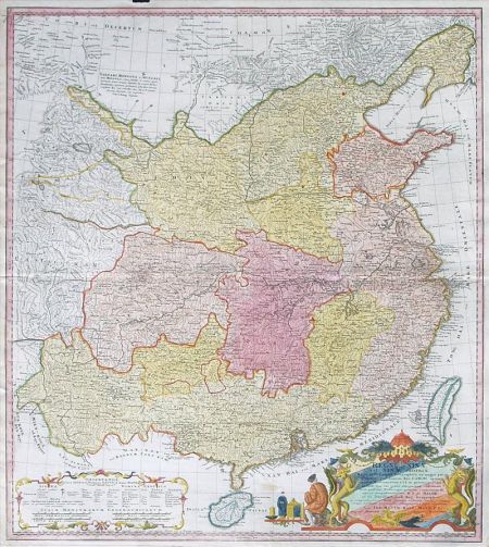
On March 28, German Chancellor Angela Merkel hosted visiting Chinese President Xi Jinping at a dinner where they exchanged gifts. Merkel presented to Xi a 1735 map of China made by prolific French cartographer Jean-Baptiste Bourguignon d'Anville and printed by a German publishing house. According to an antique-maps website, d'Anville's map was based on earlier geographical surveys done by Jesuit missionaries in China and represented the "summation of European knowledge on China in the 18th-century." The map showed, according to its original Latin caption, the so-called "China Proper" -- that is, the Chinese heartland mostly populated by ethnic Han people, without Tibet, Xinjiang, Mongolia, or Manchuria. The islands of Taiwan and Hainan -- the latter clearly part of modern China, the former very much disputed -- are shown with a different color border.
Historical maps are sensitive business in China. Every schoolchild in China learns that Tibet, Xinjiang, Taiwan, and the Diaoyu Islands have been "inalienable parts of China since ancient times." The d'Anville map, at least visually, is a rejection of that narrative. Unsurprisingly, China's official media outlets don't seem to have appreciated Merkel's gift. The People's Daily, which has given meticulous accounts of Xi's European tour, elided any coverage of the offending map. More curiously, when news of the map's presentation reached the Chinese heartland, it had somehow morphed into a completely different one. A map published in many Chinese-language media reports about Merkel's gift-giving shows the Chinese empire at its territorial zenith, including Tibet, Xinjiang, Mongolia, and large swaths of Siberia. This larger map was the handiwork of British mapmaker John Dower, published in 1844 by Henry Teesdale & Co. in London, and was certainly not the gift from Merkel to Xi. But this mistake was not noted or explained in Chinese reports.
Both versions of the Merkel map have made appearances on Chinese social media, eliciting vastly different interpretations. Those who saw the d'Anville map seemed shocked by its limited territories. Hao Qian, a finance reporter, remarked that the map is "quite an awkward gift." Writer Xiao Zheng blasted Merkel for trying to "legitimize the Tibet and Xinjiang independence movements." Architect Liu Kun wrote, "The Germans definitely have ulterior motives." One Internet user asked, "How is this possible? Where is Tibet, Xinjiang, the Northeast? How did Xi react?"

The Dower map, on the other hand, seemed to stoke collective nostalgia for large territories and imperial power. An advertising executive enthused, "Our ancestors are badass." Another Internet user hoped Xi would feel "encouraged" by the map to "realize what a true re-emerge of China means." Some suspected that Merkel tried to send Xi a subtle reminder that Russia had helped Mongolia declare independence from China in the mid-20th century, somewhat like what Russia did in Crimea in March 2014.
To be sure, the d'Anville map does not constitute a total contradiction of the Chinese government's version of history. In 1735, the year when the Qianlong Emperor began his six-decade reign, his Qing empire's military prowess was on the ascent. Qianlong quelled a rebellion by Muslims in the western region of Xinjiang, brought the Mongol tribes under closer rule, and appointed officials to oversee affairs in Tibet such as the selection of the Dalai Lama. In other words, Qianlong established the trappings of imperial control over these peripheral territories, which allowed later governments -- the Republic of China, then the current People's Republic of China -- to claim sovereignty. Maps published by Western countries in the 19th and early 20th centuries vary in their presentations of Tibet and Xinjiang, but the Dower map is certainly not alone in showing Xinjiang and Tibet as parts of the Chinese empire.
All the cartographic brouhaha may be overblown. One Internet user refused to "overinterpret" the d'Anville map as a message about Tibet or Xinjiang. After all, "You can't use a map of the 13 colonies of the United States made in 1776 to tell Americans that Texas or California is not U.S. territory." - Foreign Policy